


Road biking in south Piedmont
 Hi to all cycle-riders,
road-biking in the south of Piedmont is rather popular because there are a lot of tracks and roads to discover and the landscapes are very nice (wineyards, hills, small mountains, green fields ....... etc.). There are also a lot of paths for MTB but, in this section, I'll speak about the roads for race-bikes only.
In this area there is one cycle track only (it's called "Fausto & Serse Coppi, Circuito di Castellania"), you have always to cycle on the same roads of the cars (pay attention!).
The following ones are all routes for race-bikes but someone can also be covered with good city-bikes or with MTB with slick tyres; however, all flat routes can be easily cycled with city-bikes. I've tested them with my Specialized Roubaix Elite 2005 and I've covered 4700km in year 2006. I cycle for the sake of doing it, I don't take part in any contests.
All the routes leave from Ovada; the directory begins from the shortest routes until arriving to the longest ones; the kilometers are merely indicative even if on my road bike I've got the odometer. Unfortunately, during spring and also at the beginning of summer, Ovada and the zones near this town are whipped from the wind and in some days the weather is very windy (it's not easy cycling against the wind, it seems to be in The Netherlands!) Some routes may have some towns in common, it's possible to connect two or more routes and make a longer trip.
Ride your bike, wear your bike-helmet, start bicycling and find your rhythm, new routes will be added asap.
Even if you've a hard head, wear the helmet!
Maps:
- ViaMichelin
- GoogleMaps
Italian signs and roads: http://www.slowtrav.com/italy/driving/introduction.htm (this site is very useful and well done in my opinion)
Where can I hire the bikes?
Ovada (Al): Guizzardi Cicli, http://www.cicliguizzardi.it/ , here you can rent MTB, city bikes and road bikes. This store is a Specialized Dealer but here you can find other bikes, gloves, shirts, jackets, tights, socks, helmets, optics, cages, cyclo-computers, tires ........... and a repairing centre.
Where can I sleep?
Ovada (Al): L'Hotellerie, it's a new building opened in year 2006, it's located at "Polisportivo Geirino"(that is a multi-purpose sporting centre), breakfast upon request, double and single rooms are available, phone: 
At "Polisportivo Geirino" there are: two soccer fields, two tennis courts, one polyvalent court (five-a-side football or tennis), one athletics track, one small sports stadium (basketball, volleyball .... etc.).
Are you looking for a B&B or another accomodation? Look at these Farm Houses Associations:
- http://www.agriturist.it/
- http://www.terranostra.it/
- http://www.turismoverde.it/
Otherwise, you can contact the Tourist Office in Ovada (= IAT),
phone: +39-0143-821043,
address: Via Benedetto Cairoli n° 103, Ovada
Weather:
Weather in Piedmont
Italy, weather and maps (Piedmont)
Note:
SP = Strada Provinciale = Main road
SS = Strada Statale = Main road or trunk road (it's more important than the SP road)
Photos: you can see some photos taken by me in this post and this one.
[16.4 KM] CYCLE TRACK "FAUSTO & SERSE COPPI, CIRCUITO DI CASTELLANIA" - CARBONARA SCRIVIA-VILLAROMAGNANO-COSTA VESCOVATO-CAREZZANO SUPERIORE-PADERNA-SPINETO SCRIVIA-CARBONARA SCRIVIA:
It's a cycle track (we've got few cycle tracks in this area!) of recent construction, it was built in the zones of the two famous cyclists, it has been inaugurated on 28 Jul. 2005 and leaves from the Sporting Center of Carbonara Scrivia. Main features:
- quota of departure: 156mt (Carbonara S.)
- the maximum quota: 385mt (Bric of the Witches)
- total gap: 270mt
- the maximum slope: 8%
- areas pause: 3 (Carbonara S. - Villaromagnano - Costa Vescovato)
- parkings: 1 (Carbonara S.)
I have finally tried this track on Sunday (Apr. 15, 2007) in the afternoon; first of all, is not long 6,5 km as it has been written in the article of the Italian Newspaper "La Stampa" but it's 16,4 km of which 8 km are, exclusively, of cyclabile track. Nice landscapes!
Do you want to know something more about Fausto Coppi? Look at the Web Site http://www.faustocoppi.it/
LINKS: map of the cycle track
[30.2 KM approx] OVADA-CARPENETO-CASCINA VECCHIA-ROCCA GRIMALDA-VILLA BOTTERI-OVADA:
Main features: climb for a pair of km in S. Bernardo Road (the street is rather damaged in some places) and various easy up/down, other climbs are met before arriving to Rocca Grimalda and Villa Botteri. The roads are almost calm, you can see fields, vineyards, forests, greens valleys (nice landscapes). I like cycling in these zones; early in the morning or late in the afternoon you can see the peasants in the fields with the tractors or working in the vineyards.
Departure from XX Settembre Square in Ovada, exit from this square, at the roundabout take the 4th exit on the right (Saracco Street); after few meters, turn right in Ruffini Street, pass in front of the Hospital and continue straight on this road until you reach a stop sign. At the stop sign, turn left into SP204 Road (direction: Grillano) and, after a hundred of meters (in front of the Sporting Center "Geirino"), turn right into S. Bernardo Road. After some flat metres, the road climbs until to reach the SP200 Road (about 4,9 km from departure). At the crossroad turn left and, at the next crossroad, turn right (direction: Carpeneto), when you arrive in the small town (about 8,5 km from departure) pass it and then take the SP190 Road (direction: Cascina Vecchia/Mantovana/Castelferro). At Cascina Vecchia (few houses around one orange blinking traffic light), turn right into the SP189 Road (direction: S. Giacomo/Schierano). Near the small town of San Giacomo the road turns right (dangerous curve, pay attention!!), after some curves downhill and a short climb, you arrive to a crossroad, turn right towards Rocca Grimalda. The first part of this road (SP191) climbs, cycle along this road until you arrive in proximity of the Cemetery of Rocca Grimalda. Pass near the entrance of the Cemetery and follow the indications for Carpeneto. At the roudabout, turn left towards Carpeneto and continue on SP199 Road (it's a panoramic road). Continue on that road and omit the two streets that you find (the one on the right goes to Carpeneto while the one on the left goes to S. Lorenzo). You arrive to the small village of Villa Botteri, keep the the main street and, at the next crossroad, turn left into SP200 Road, this road goes to Ovada (about 30,2 km from departure). The SP200 Road is a nice downhill among the vineyards and green hills.
LINKS: my map
[36.5 KM approx] OVADA-MOLARE-CREMOLINO-MORSASCO-TRISOBBIO- VILLA BOTTERI-ROCCA GRIMALDA-SCHIERANO-OVADA:
Main features: climb for a pair of km between Molare and Cremolino, various easy up/down between Cremolino and Morsasco, other climbs are met before arriving to Trisobbio and Villa Botteri. The roads are almost calm (except the road SS456); you can see fields, vineyards, forests, greens valleys (nice landscapes). I like cycling in these zones; early in the morning or late in the afternoon you can see the peasants in the fields with the tractors or working in the vineyards.
Departure from XX Settembre Square in Ovada (altitude: 186 mt.), exit from this square and turn left into Martiri della Libertà Street, after two traffic lights you arrive at the roundabout, turn right into Italia Street and keep this way until its end. At the next roundabout turn left into Molare Street (it's the SS456, pay attention because it's very busy!) until you arrive at Molare (altitude: 226 mt.). Pass it and follow the road SS456 (direction: Cremolino), after the town of Molare the road starts climbing. After few kilometers you arrive at Cremolino (altitude: 374 mt.). This small town is very nice and it's fortress has a commanding position. Continue on the main road and follow the direction for Acqui Terme. Leaving this town, the road begins to come down, after 2-3 curves, turn right into the street that climbs steeply. At the crossroad turn left into Rissa Street, in the past this road was partially asphalted but now it's completely asphalted; it's very narrow, pay attention! After few kilometers you arrive at Morsasco (it's a nice small town too) whose altitude is 328 mt.
Pass into Belvedere Street, until you reach a very small church, follow the street on the right and then pass into Gramsci Street. This street ends at the stop sign, turn right into Umberto I Street (you're in the middle of the ancient town, it's a very narrow street) and then follow the directions for Alessandria. Exit from Morsasco and follow the main street (SP202), this road goes down with some curves. Keep the main road and pass near a big industry "Trafilerie Cavanna" until you arrive at a stop sign. Turn right and follow the main road (SP200) until you arrive at Trisobbio after a long and rather hard climb. The altitude is 341 mt. Continue on the main road (SP200) and follow the directions for Ovada, firstly the road goes down and then another long climb starts (it's 1 km approx). On the top of the hill you can see two roads on the right but you have to continue on the main road (SP200), after 150 metres you can see other two small roads on the left. Turn left and follow the directions for Villa Botteri; the sign is damaged and it's rather difficult to be seen, look at the following map:

Cycle along the small road, pass through the village of Villa Botteri and continue on the main road until you arrive at a stop sign (take care because it's at the end of a downhill! The stop sign is approx 1,9 km away from Villa Botteri). At the sign stop follow the road which is in front of you (SP199) until you arrive at a small roundabout, turn left and pass near the entrance of the Cemetery and remember to stop at the stop sign that is at the end of this short road (it's approx 200 metres away from the roundabout)! Take care: the stop sign is hidden by some trees!
Turn into the road which is in front of you (SP191) and continue on the main road until you arrive at a crossroad after 2,9 kilometers (firstly the road is flat then it slopes down). At the crossroad, turn right into the main road (SP185) and follow the directions for Ovada. After 7 kilometers you reach the starting point (XX Settembre Square).
LINKS: my map
[63.9 KM approx] "ALPINO-TOUR": OVADA-BELFORTE MONFERRATO-CASALEGGIO BOIRO-MORNESE-CAPANNE DI MARCAROLO-CAMPO LIGURE-OVADA: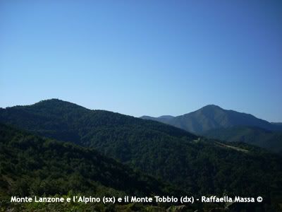 Main features: climb for a pair of km before Belforte M., various easy climbs and downhills, other climbs are met before arriving to Mornese. Two hard climbs between Mornese and Capanne di Marcarolo; you can see fields, forests, greens valleys (very nice landscapes). You cycle through the Park "Capanne di Marcarolo", it's one of my favourite tours.
Arriving to the Mount Lanzone and then to the area called “Capanne di Marcarolo” repays your weariness. You cycle through the Park "Capanne di Marcarolo" and you see woods, green valleys, meadows and bare hills. The road, especially early in the morning, is not busy and the area is pratically uninhabited. It’s a rough landscape but I love it and I hope that you like it too.
This is one of the places of the Resistance during the 2nd World War, before arriving to the area called “Capanne di Marcarolo” you pass near the ruins of the “Benedicta” Monastery, in this place were killed 147 Partisans by the German soldiers between 7 Apr. 1944 and 11 Apr. 1944. Now this area is known as “Sacrario della Benedicta” (sacrario = memorial) and near the ruins there are some stelae with the names of all killed Partisans.
This route can be covered preferably during spring, summer (leaving early in the morning, don’t go in the hottest hours!) and at the beginning of autumn.
Leave from the Square in front of the (elementary) primary school in Ovada, it’s called “Martiri della Benedicta” Square. Turn into “Martiri della Libertà” Street and at the roundabout take the 2nd exit and continue along this road (follow the green road-sign for “Autostrada” that is the motorway). At the next roundabout take the 1st exit and follow the green road-sign for Autostrada again. You arrive to another roundabout, turn left and take the 2nd exit (go on following the directions for “Autostrada”), pass over a bridge. At the next roundabout, take the 3rd exit and follow the directions for “Belforte Monferrato”, the road SP170 starts climbing. After 3 rising curves you arrive to “Belforte Monferrato” (altitude: 297m; distance: 3km from start). Pass through this village (pay attention because the road is very narrow and it goes on rising!) and follow the directions for “Tagliolo Monferrato/Lerma”.
Follow the directions for “Tagliolo Monferrato” and continue along the main road (SP170), you encounter some easy slopes/descents. After few kilometres (approx 1,5 km), turn right into a narrow road and follow the road-sign “Regione Mongiardino / San Pietro”. Continue along this road until you arrive to a crossroad (this area is called “Regione Gambina”), turn right and follow the directions for “Lerma”; after two downhill curves, the road SP170 turns right. Go on the main road, following the directions for “Lerma” again. You pass over a bridge and then the road SP170 starts climbing. After few metres after the first curve on the right, you encounter a plaque which commemorates the sacrifice of three young Partisans during the 2nd World War, turn in the narrow road on the right. No road-sign points out this road, take the plaque as a reference! This narrow road is a nice secondary road that pass through a wood and you cycle along easy slopes/descents. After few kilometres you see 2-3 small roads on the right but you have to continue along the mail road until you arrive at a crossroad at “Casaleggio Boiro” (altitude: 321m; distance: 12km from start). Turn right and follow the directions for “Mornese”. Before arriving to this crossroad, turning your eyes right, you can see the ancient Castle of “Casaleggio Boiro” on a spur. It was built in the X Century.
Continue on the main road (SP170) until you arrive at “Mornese” (altitudine: 380m; distance: 14,35km from start). At the crossroad turn right and follow the road-sign for “Bosio”. The road (SP170) starts climbing and after few curves you pass through the area called “Mazzarelli” and you can see the Shrine dedicated to Saint Maria Mazzarello. Continue on the main road (SP170) and exit from “Mornese”, the climb raises progressively.
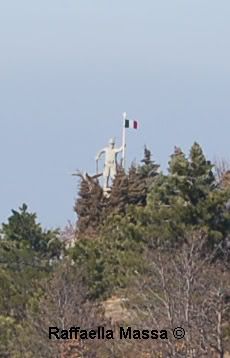
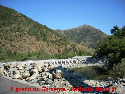
After some curves at a crossroad (altitude: 418m) turn right into the road and follow the directions for “Voltaggio / Capanne di Marcarolo”. This road starts climbing hardly, welcome to the “Alpino” tour!!! The road SP165 climbs for approx 6km continuously (average gradient: 6%, maximum gradient: 8,5%), leaving early in the morning from Ovada, this climb is rather shaded. In summertime, in order to avoid the hottest hours, it’s better to start this route early in the morning! After the long climb the road starts descending and you arrive at a crossroad (this area is known as “Località Eremiti”), keep the right and follow the directions for “Capanne di Marcarolo / Campo Ligure”. The crossroad is at the foot the Mount Tobbio and it’s pointed out by a ranging rod and a small chapel. Mount Tobbio is the highest mountain in the Park, it’s 1092m and behind the chapel start some paths that reach the top of this mountain (on the top there's a small white church, it's a shelter of Italian Alpine Club). Continue cycling on the main road SP165, the scenic route follows two streams (Eremiti and Gorzente), this road climbs and goes down for approx 4,5km until it decends steeply until a ford on Gorzente stream (altitude: 482m).
After this ford the road SP165 starts climbling hardly for approx 5-5,5km, clench your teeth and cycle! The maximum gradient is 9%, the average gradient is 6,3%, note that this route is rather sunny even if you pass through the wood. The road pass near the ruins of the "Benedicta" Monastery, some posters explain the history of the massacre. The road goes on climbing and after few kilometres you reach an equipped area for pic-nic (it's called "I Foi") and then the area called "Capannne di Marcarolo" (altitude: 750m, distance: 37km). Here's a bar-restaurant. Continue along the main road and at the crossroad turn right (direction: "Campo Ligure"), the road SP165 descends in the middle of green woods pleasantly. Continue along the main road (first it's SP165 then it becomes SP69) and after some kilometres you arrive to "Campo Ligure" (altitude: 342mt, distance: 47km). Reach the road SS456 and follow the directions for Ovada, after 16.9km you return to the starting point. Pay attention beacuse the road SS456 is rather busy and you can find a lot of fast and undisciplined bikers!
PHOTOS: Alpino - the ford on "Gorzente" - the Park "Capanne Marcarolo"
[65 KM] "LOW MONFERRATO TOUR": FELIZZANO-FUBINE-OTTIGLIO-GRAZZANO BADOGLIO-CASORZO-GRANA-MONTEMAGNO-CASTAGNOLE MONF.-REFRANCORE-PIEPASSO-QUATTORDIO-MASIO-FELIZZANO:
Main features: it’s a circular tour in the hilly area among Alessandria, Casale and Asti (it’s called Low Monferrato). You encounter some climbs before the following tows: Grazzano Badoglio, Casorzo, Grana, Montemagno, Castagnole Monferrato and between Refrancore and Piepasso. The remaining way is rather flat and you find some easy slopes/downhills. Landscape: pleasant hills, fields and meadows, wineyards, villages with old castles and ancient churches. The Italian poet/writer Giosuè Carducci (1835-1907) had defined this area as “Tuscany without the cypresses”. In fact some of these landscapes look like the landscapes of Tuscany. Some villages on the top of the hills are very nice and the route is rather scenic. On the contrary, the area near Quattordio, is very bad and ugly because it’s an industrial area. Unfortunately your have to pass through Quattordio in order to return to the start (I’m looking for another road in order to cut out Quattordio from this tour).
Departure from Felizzano: at the roundabout that has been recently (winter 2008) built in the crossroad where the SS10 meets the SP77, follow the road markings to Fubine. Continue along the flat road SP77 until you arrive at a crossroad after few kilometres. Turn left and follow the road markings to Fubine (you can see this small town not far from the crossroad). Pass it and continue along the main road SP77. There’s a short and easy climb in the area called “Fugassa”, right after Fubine. You arrive at a roundabout, turn right (take the 1st exit) and follow the road markings to Vignale Monferrato. Not long after you encounter a climb, longer and harder than the previous one, on the top (14 km) continue straight along the main road SP77. The road descends and, when you arrive to the area called “Orti”, turn left and follow the signs for Ottiglio. Pay attention when turning because there are two roads: one takes to Frassinello, while the other takes to Ottiglio. Take this one (it’s the extreme left road)! The road SP48 is pleasant, pass through fields and hills and it’s not a busy street. At Ottiglio (22.6 km) turn left and follow the road markings for Grazzano Badoglio. In my opinion, the nicest part of the cycle-tour starts from Ottiglio and ends to Castagnole Monferrato. The landscapes are very pleasant, especially during spring and summer!
After few easy climbs/downhills the road starts climbling much more hardly. The road (first SP37 then SP30b) arrive to Grazzano Badoglio (25.6 km), in this village was born Pietro Badoglio in 1871 (he was an Italian General during 2nd World war).
.
![]() Etichette:
bicycle,
bicycling,
bikes,
cycle,
cyclist,
Piedmont,
race-bike,
race-bike tours,
road biking,
road cycling,
south Piedmont
Etichette:
bicycle,
bicycling,
bikes,
cycle,
cyclist,
Piedmont,
race-bike,
race-bike tours,
road biking,
road cycling,
south Piedmont


